
My Best GeoGuessr Plays: Version 3.0
In case it wasn’t already abundantly clear, I am a fan of GeoGuessr.
We all know how this game works by now. They show you some imagery from Google Street View and you have to figure out where you are. In the words of Jeffrey Dean Morgan, where the “X” are you? Well, here are a handful of rounds I’ve played since the most recent time I wrote an article about this. So enjoy.

Google Street View footage (within the GeoGuessr interface) of a restaurant called “Amore Ristorante & Pizzeria” in a northern European setting.
I first need to mention that I’ve taken to playing No Move instead of Moving. I honestly prefer this mode, as it’s fairer when both players have the same information with which to make their guess. That is, if they choose to analyze everything at their disposal before sending their plonk.
In any case, as you can tell from the image, the game’s RNG put me right in front of a pizza restaurant. Pizza is, of course, the most famous dish in the world - it needs no introduction. It’s often associated with Italy, but the building’s architecture appeared far more austere and utilitarian than what you’d likely find in Italy. It’s the sort of building you’d feel belongs in a colder climate. Additionally, the coverage just looked “colder”, possibly because the locals were wearing thick jackets.
I might not have been able to move down the street, but I could still pan the camera around to see some other buildings. And that’s when I felt certain I was not in Italy.

Google Street View footage, within the GeoGuessr interface, of a town with Scandinavian architecture and a small mountain in the distance. It looks like late autumn.
The text on the signs not affiliated with the pizzeria bore a language that seemed Scandinavian to me. This stood in stark contrast to Italian, in which the great majority of words end in a vowel. And yes, Italy has mountains as well, but that red house-like building in the corner isn’t what you’d see in an Italian villa.
So I had a decision to make. The architecture made me inclined to send Norway, coupled with the nearby mountains - Denmark, Sweden, and Finland are much flatter countries on average. Because there was a pizzeria, and I tend to think of pizza as a dish served mostly to tourists rather than locals, I decided to go with Alesund. This city, located on Norway’s west coast, is a popular tourist destination near some of the country’s most well-known fjords.
As it turned out, the precise location was in the town of Stjørdal, closer to the Swedish border than I would have liked. However, it ended up mattering little, because my opponent did in fact guess Italy! They must’ve let the pizzeria get to them.

Google Street View footage of northern Israel within the GeoGuessr interface. A small purple truck can be seen advertising cannabis products.
This one was just plain silly.
I was playing Moving, and the setting was pretty dry, with the trees to match such a climate. My first thought, upon seeing those trees, was that I was near the Mediterranean Sea. I had one specific country in mind, and it was confirmed when I saw the purple truck.
One of the most important skills any GeoGuessr player must acquire is the ability to recognize languages. You need not know what the words mean all of the time, but it’s imperative to be able to tell Dutch from Turkish, for example. If not for this game, I probably wouldn’t know that Romanian was a close relative of Italian!
In any case, when I saw the characters that resembled musical notes, I knew I was looking at Hebrew script. I’ve seen plenty of dreidels with such letters on them, though I couldn’t tell you what each symbol is called. Again, you just need to know that it’s Hebrew, not what it’s telling you in Hebrew.
There is only one country where Hebrew is an official language. Only one: The State of Israel.
Now, given what country I’m talking about, I want to make one thing perfectly clear: I am no fan of Benjamin Netanyahu. He’s a genocidal maniac. As far as GeoGuessr goes, however, I am politically neutral with regards to the Israel-Palestine conflict. I only concern myself with it when it relates to practical in-game knowledge.
More importantly for this blog, the truck is hilarious. Maybe only one country uses the Hebrew script to write, but we all know what that leaf means when it’s on a corporate logo. That’s right: This is a weed truck.
I just…that’s too funny. Israel is a country that’s despised by many progressives in the United States and elsewhere, and for good reason. Meanwhile, cannabis has been decriminalized mostly in relatively progressive nations like the Netherlands, and movements in the United States to make it more accessible for medical and recreational use are associated with progressive ideals. However you might feel about the drug laws in the United States, the Netherlands, Israel, or anywhere else, this juxtaposition made me laugh to no small degree.

Google Street View footage (within the GeoGuessr interface) of a mountainous town in northeastern Turkey.
I played this round earlier today (as of when I wrote this article). Based on how low both of our health bars were at this point, and that the multiplier was at 3x, I felt confident that this round was what they call sudden death.
As soon as I saw the sign on top of a nearby hotel building, I knew with absolute certainty what language it was in. The Turkish language has a very unique look, with its squiggly lines and other symbols. Additionally, I saw a Turkish flag near that same hotel building.
If you know the area code patterns in Turkey, it’s fairly easy to region-guess the country. All you need to remember is that “2” area codes go in roughly the westernmost quarter of the country, “3” area codes are in the next third of Turkey, and area codes starting in “4” are assigned to the rest of Turkey, from the middle of the country all the way to the borders with Georgia, Armenia, Azerbaijan, and Iran. That is your “Turkish Delight” as opposed to your “American Bad Dream”.
However, there’s a catch. If you’re in Turkey and see a phone number starting with “5”, then that phone number is useless, because the “5” area codes aren’t tied to a specific location. I found a “508” number that would belong to Türk Telekom, the state-owned telecommunications company, so I knew that wasn’t going to help me.
Of course, my general rule of thumb for Turkey is that the more moist and mountainous the landscape is, the more likely you are to be toward the west of the country. This place looked like it might be a ski resort during the winter - the hotels would make sense in that case. But before I plonked in the southwest of the country, it occurred to me that northeastern Turkey is also quite mountainous. Therefore, I decided to guess there.
Well, considering that my opponent sent Romania, I took home the Elo points for that round. There’s something viscerally satisfying about spotting a clue the other player misses, and I got to revel in it today. This is why I keep coming back to GeoGuessr, even though I became quite frustrated at first upon being promoted to Master II. (I expect to be demoted pretty soon, just because these players are making mincemeat of me, but that’s another story).
Thank you for reading, and keep an eye out for my next GeoGuessr article.
My Best GeoGuessr Plays: Version 2.0
Hello. As all of you know, most likely, I’m a big fan of GeoGuessr. You know it - it’s the computer game where you get plopped somewhere on Google Street View and you have to guess the location. In today’s article, I’ll be listing a few of my most memorable rounds since my last article three weeks ago.

Google Street View imagery within the GeoGuessr interface. Large detached homes with small lawns and abundant palm trees can be seen.
This round looks like any other upscale suburb from the American Sun Belt. That is, until you see the street signs!
In this round I saw giant McMansions amidst palm trees. This area looked relatively car-dependent, and at first I was convinced I might be in Florida. After all, given the vegetation and architecture, it looks like it could be down the street from Mar-a-Lago. They say lots of places are starting to look the same these days, but what do I know?
But then I saw a white street sign, which is instantly a red flag if you’re tempted to guess in the United States. As most people who watch American movies will be well aware, our street name signs are green. The signs in this location were in English, suggesting an Anglophone country, but the cars were driving on the left. My first thought was Australia.
That in itself presents an issue, however, because Australia’s a pretty big country. Given the sheer number of palm trees present, I felt like it was Queensland as opposed to New South Wales or especially Victoria. So I ended up plonking just south of Brisbane, near the city of Gold Coast. And, lo and behold, I was correct, earning a point value in the 4700s.
Now, here’s the memorable part: My opponent guessed in the United States. And again, this was a Moving game, so they might not have had the same information as me. If not for the street signs and driving direction, it would be easy to guess southern California or Florida. However, my opponent guessed a location in the Midwest, which has no palm trees. At least, no palm trees that grow naturally! Needless to say, this guess got me the win against one of the dumbest opponents I’ve ever faced.

Google Street View imagery within the GeoGuessr interface. There is a wooden utility pole with a sign visible on it. This sign advertises a sealcoating/paving company with a phone number starting in 508.
I’ve previously written about how difficult it can be to region-guess the United States. I’m on record saying that trying to memorize all the hundreds of area codes might end up with you “smearing excrement on the walls of a padded room”. And to some extent, I stand by that assertion.
You see, Turkey’s area codes are intuitive. Phone numbers beginning with 2 are in the western part of the country, those starting with 3 are in the middle of the country, and Eastern Turkey is served by area codes that start with 4. This makes sense, so it’s no wonder why the United States doesn’t do it this way. Rather than the “Turkish Delight” of simpler area codes, memorizing those in the USA might end up an American Bad Dream.
That being said, if you do know America’s area codes without going insane, power to you. It’s the best tool to regionguess the country, and it’ll almost always be enough to win that round unless your opponent is someone like Trevor Rainbolt. It also helped me during one particular round last week. As you can tell, a phone number featuring the 508 area code is visible, and as a Massachusetts resident myself, I knew that this code serves the Worcester area, the South Shore/Buzzards Bay region consisting of Bristol and Plymouth Counties, Cape Cod, and the islands of Martha’s Vineyard and Nantucket. In fact, I’d seen a sign for “Bristol”, giving me a general idea of where to look for this code.
I scored in the low 4900s on this location in Westport, Massachusetts. Even though I ended up choking on the resulting comfortable lead, I still consider this round memorable because you never know what will come in handy.

Google Street View imagery (within the GeoGuessr) interface of land surrounding an oil refinery in a somewhat dry tropical climate. The street has double yellow central lines.
Oh boy. This one was a doozy.
I found myself in a tropical setting that otherwise looked like the United States. Street signs were green, and the signs said “SPEED LIMIT” rather than Canada’s “MAXIMUM” (not that Canada has any tropical zones) or Puerto Rico’s “VELOCIDAD MÁXIMA”. That’ll be important later. Additionally, the road’s center lines were deep yellow, and there were two of them.
My first thought was Hawaii. As you can tell from the images, this was an industrial zone containing what looked like an oil refinery. Clearly, this is not the Hawaii of the brochures and Instagram reels.
I guessed Kauai, and I’m not sure exactly what possessed me to send Kauai rather than the more populated and industrialized island of Oahu. This cost me a couple hundred points (giving me a score in the 4600s as opposed to the 4900s). However, it only prolonged the match by one round, because my opponent guessed Puerto Rico.
Now, I suppose Puerto Rico does have a strong petrochemical industry. That’s what this Wikipedia article suggests, after all. It’s kind of ironic that Wikipedia has now become The One Reliable Source™ that must be Defended At All Costs™, but that’s America in 2025. In all seriousness, watching the replay, it looks like my opponent made a “panic guess” after I sent Hawaii and they only had fifteen seconds to plonk.
If they’d seen what I saw, though, I don’t think they would have guessed Puerto Rico. And I saw possibly the funniest thing I’ve ever seen on street view while playing GeoGuess. Get a load of this:

Google Street View imagery within the GeoGuessr interface of a building advertising “Aloha Petroleum, Ltd.”
This honestly could have been its own article. I’m now aware that “Aloha Petroleum, Ltd.” is a chain of gas stations serving Hawaii that has about 60 locations. Of course, it’s no surprise that Hawaii is car-dependent like most of the rest of the United States. We can have a conversation any time about how, in the words of one Joni Mitchell, they paved paradise to put up a parking lot. But let’s leave the big yellow taxi alone.
Seriously, look at that. Aloha Petroleum. This felt Orwellian to me. Like, “Aloha”, the well-known Hawaiian word for both “hello” and “goodbye”, is associated with paradise on Earth. It’s the word you’re greeted with upon landing at Daniel K. Inouye International Airport in Honolulu, along with (allegedly) a flower necklace called a lei. At least, that’s what popular culture would have us believe.
So to put that word associated with a beautiful place with environmentally conscious people, and plop it right next to one of this world’s most destructive industries…it’s darkly comical. It reminded me of sayings like “alternative facts” or that time Donald Trump told a rally crowd in 2018 to disbelieve their own eyes and ears.
It’s like: War is peace. Freedom is slavery. ALOHA PETROLEUM!
There are plenty of debates about whether it’s ethical to visit Hawaii. Truth be told, lots of people abroad are questioning whether it’s ethical, or even safe, to visit the United States in general at present. I’m not naïve to the fact that international tourism in the USA is down like 20% and will probably fall further. But this particular conversation isn’t really about America generally - it’s about Hawaii specifically. Some people say Hawaii should have been an independent nation as opposed to a tourist mecca for people from the American mainland. Here’s an article I think is fairly grounded, which describes reasons why some people say you should never visit Hawaii.
Anyway, these are three notable rounds from the last few weeks of GeoGuessr. Thank you for reading!
American Bad Dream: GeoGuessr Edition

A map of the United States that proves the four-color theorem and contains postal abbreviations for each state. Image from Wikipedia.
The United States was not built with GeoGuessr players in mind.
Now, to be clear, the engineers, architects, and blue-collar construction workers who brought the country’s infrastructure to life (even with all the problems it’s brought us) were under no obligation to make matters convenient for future players of a computer game. They had enough problems as it was.
The fact remains, however, that the way this country’s infrastructure was set up renders it very difficult to tell what state you’re in on Google Street View. In other words, region-guessing the United States can turn into an American Bad Dream.
I am aware that the Kane Brown song “American Bad Dream” is about gun violence, a topic that isn’t funny at all. Indeed, it’s horrendously tragic that we’ve lost so many people to so many acts of it. That’s far worse than whatever happens to people as a result of playing GeoGuessr
But let’s look at some maps, shall we? It’ll tickle the ‘tism, as someone in one of my Discord servers put it. And it’s always fun to do that!
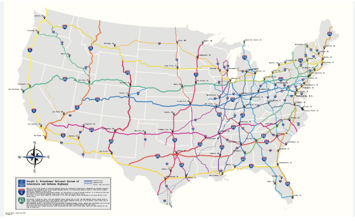
A map of some interstate highways in the United States. Image taken from r/MapPorn.
If you know the general pattern of the Interstate system, conceived by President Eisenhower (or at least, named after him), you can narrow your guess down pretty effectively. The numbering scheme was at least designed in an intuitive manner. It was really a pretty remarkable feat of engineering and one thing to almost be proud of if you live here. More on that later.
Anyway, even-numbered highways run east to west across the contiguous 48 states, and their numbers increase from south to north. They show up on the mini-map you use to send your guess, so you don’t necessarily need to memorize them. As for the odd-numbered highways, they run north to south, with numbers increasing as you move eastward. Again, they’re on the mini-map, so it shouldn’t be too overwhelming.
However, it gets more difficult when you consider state highways. Much more difficult. But as with the interstates, there is at least some method to this madness. This article lays it out more vividly than I feel like doing. However, these state routes (not to be confused with “interstates” that happen to only be in one state) are given triple-digit numbers according to a different scheme. That scheme varies according to the state, so it’s of only so much use if you don’t already have a good idea what state you’re in.
And the highway numbers are all the help you’ll get in terms of infrastructure!

A gallery of license plates for all 50 US States as of 2023. Image taken from r/coolguides.
These are the current license plates for every state. At least, they’re the most current plates I was able to find. And of course, in the last few years some states have changed their plate design for a number of reasons (sometimes adjacent to being more sensitive to racial issues). This means that sometimes, especially in older coverage, you’re going to see previous designs of license plates. For our purposes, suffice it to say that it’s a pain in the ass trying to memorize them all. A lot of them look fairly similar to each other.
There are also a few reasons why license plate meta is only so useful in the United States. First of all, most license plates are blurred on Google Street View. That’s not even exclusive to the USA. If you can recognize any distinguishing features of license plates beyond color through the blur, you’ve got better eyes than me. Either that, or you’re going to strain your eyes to an extent that’s not worth it for a mere computer game.
But wait! There’s more!
You see, infrastructure in the United States is very often centered around automobiles to an unhealthy extent. This is in no small part due to the interstate system; for all the economic growth it has brought the country over the years, GDP isn’t everything. Hell, some people would argue that GDP doesn’t matter very much at all, and what you should really be measuring is how the people in the middle class and below are doing. It’s also true that these highways were often built through marginalized communities, particularly those where disproportionately many people of color lived. This is a problem that, in a perfect world, would be alleviated somehow.
The reason I say this is because, even more than in countries with considerably less car-centric infrastructure, cars travel. That’s kind of why they exist. This means that you’ll often see license plates from states besides the one you’re in, particularly if you spawn on a highway.
In fact, the “long road trip” has been a common element of American popular culture for quite some time. I was never one for such trips because I hate sitting in a car for hours on end, but plenty of families still do them. The “license plate game”, in which bored family members compete to see who can spot vehicles from the most states, is also a figment of the public consciousness. So basically, license plates aren’t terribly useful for region-guessing the USA.
If you thought license plates were confusing, you’re in for a rude awakening.

A map of telephone area codes in the contiguous United States. Image taken from All Area Codes dot com.
Holy hell.
Just look at that. It’s a monstrosity. If you try to memorize them all, you might well find yourself locked in a padded room painting the wall with your own excrement. Unless your name is Trevor Rainbolt, of course.
In most other countries covered by GeoGuessr, telephone area codes make sense. At a minimum, they’re ordered in an intuitive manner. In Turkey, for instance, area codes starting with 2 are found in the western part of the country, area codes starting with 3 go in the middle, and area codes starting with 4 are in the east. That’s a reasonable way to order your phone numbers.
Let’s look back at the United States. Hell, let’s just look at my home state of Massachusetts, one of the smallest states geographically that nonetheless packs quite a punch economically. If you’ve narrowed it down to Massachusetts based on architecture, those low stone walls beside the road, or even a sign telling you what state you’re in, you still might see a phone number on an advertisement for a local business.
In Boston and its innermost suburbs, the first three digits of the phone number are 617, so that the number will be 617-XXX-XXXX. Supposedly the next couple of digits are sorted by town, but at that point the walls will smell absolutely rancid due to the resulting insanity. Anyway, correctly guessing the 617 area code will almost invariably get you the win against all but the most insane players.
Just outside of 617, when you get to the outer suburbs and some exurbs, the area code is 781. Where did the 163 numbers in between go? Well, in reality, they’re strewn all over the rest of the USA and Canada like the objects in that Calvin & Hobbes strip about opening a closet.

“Calvin & Hobbes” comic strip from June 23, 1989. If it was set these days, Calvin would probably be asking to play Fortnite, but that’s beside the point. Image taken from GoComics.
In all seriousness, once you’re past 781, you have the 508 area code that serves the Worcester area, Buzzards Bay, Cape Cod, and the islands of Martha’s Vineyard and Nantucket. Northern and northeastern Massachusetts contains the 978 area code, and western Massachusetts (including the Berkshires) uses 413. So there are five area codes, seemingly random numbers, that zigzag around the state.
And remember, that’s just one state, and a pretty small one at that as far as GeoGuessr is concerned! You still have 47 other states to memorize if you’re in the contiguous part of the country!
Look: On the list of things to be ashamed about as an American, making life difficult for GeoGuessr players is pretty far down. I’m not naïve to that fact. If anything, I think it’s pretty interesting stuff, because it serves as evidence that this game takes a lifetime to master.
Additionally, keep in mind that you can learn this information all day long, but you won’t need it very often. In my experience, European and Asian countries show up far more frequently in duels than the United States or Canada. Maybe that’s just me, though. But that’s another thing that makes GeoGuessr so hard, yet so rewarding at the same time.
My Best GeoGuessr Plays: Version 1.0
In case you didn’t know, I play a lot of GeoGuessr. It’s my favorite game. And again, if you weren’t aware of how the game works, it’s pretty simple. You’re given imagery from Google Street View and you have to guess where you are.
There are many clues one uses to play the game. The most obvious one is to pay attention to which side of the road cars are driving on - roughly 70% of the world’s countries and people drive on the right, but knowing which countries drive on the left can really narrow down your guess. Another big one is to look for signage - if you can tell languages apart when you come across a directional sign, that goes a long way to guessing the country or sometimes region.
In today’s blog post, I’m going to be showcasing a few of the most notable rounds I’ve played in which I either recognized a location with insane accuracy or learned a valuable lesson. Here we go.

Google Street View imagery of rural eastern Colorado, USA with the GeoGuessr interface.
In this round I played roughly two months ago, I spawned in a decently arid region. I could tell based on the sprawl that I was in the United States - I believe I saw a “SPEED LIMIT” sign at one point, which is important because Canada’s speed signs say “MAXIMUM” instead.
The landscape brought to mind the High Plains, and the grain elevators resembled those frequently seen in America’s agricultural regions. Of course, it’s mostly factory farms these days rather than family-owned ones, but that’s beside the point. Very often, the USA is a difficult country to region-guess because so much of it looks the same.
That was not the case here once I saw a sign for “Kit Carson”. Based on my extensive time spent studying county maps of the United States for fun, I happened to know that there is a Kit Carson County in eastern Colorado. I placed my marker there, an act colloquially referred to as “plonking”, and hoped I would get lucky. As it turned out, I did get lucky, because I won the round and, if I remember correctly, the game.

Google Street View imagery of Dublin, Ireland within the GeoGuessr interface.
This one was wild.
As soon as I spawned, I saw that the city looked decently familiar. In fact, it was almost too familiar. Exploring the neighborhood on Street View, I noticed the facade of a building called the “Liffey Trust Centre”, and that’s when I knew the city. There is only one River Liffey.
As soon as I figured out where I was, I audibly exclaimed “Holy hell!” because I had literally flown back home from Dublin the previous day. I’m not kidding. I had walked these streets a mere two days before, including an area of Dublin’s Docklands section. While I did not see the Liffey Trust Centre, which Google Maps tells me is an apartment complex, I was a mere 100 meters away from it at most.
In all probability, this was just an insane coincidence. Perhaps the game has some way of knowing where my computer has been, but that almost seems doubtful given that my IP address varies depending on what Wi-Fi network I connect to. It is possible that Big GeoGuessr, much like Orwell’s Big Brother, is always watching me no matter where I am. The algorithms know who you are, and that’s not a conspiracy theory - that’s public information. Still, it was pretty insane seeing Dublin on my interface so soon after returning from a trip to that very city, especially considering that urban rounds become a lot less frequent in duels the higher you climb in the rankings.

Google Street View imagery of Burgas, Bulgaria with the GeoGuessr interface.
Here is possibly my most impressive guess to date.
As stated at the start of this post, a truly informed play in GeoGuessr must involve looking at several clues. It’s not always enough to see an Internet domain or national flag. In this case, I saw neither.
The first thing I noticed was a series of austere high-rise apartment buildings that are informally referred to as “commie blocks.” This told me I was likely in Eastern Europe or Central Asia, a hunch that was further confirmed when I saw signs in the Cyrillic alphabet that’s used in languages such as Russian.
However, the roads were a lot better maintained than what I’d expect in Russia or especially Ukraine. While I’m not great at telling when the street-view imagery was taken, that would have been another clue. For obvious reasons, Google Street View hasn’t updated its coverage of Ukraine or Russia for several years.
My final clue was the vegetation. The trees reminded me of the time I visited Greece some years ago, evoking Southern Europe and the Mediterranean Sea. However, the specific type of apartment buildings I saw made me believe I was in a formerly communist country. And the height of said buildings implied a city of some size.
I guessed Burgas, which is the fourth-largest city in Bulgaria and a semi-popular tourist destination on the Black Sea coast. As it turns out, I ended up plonking less than a mile from the flag, being rewarded with 4,997 points out of a possible 5,000. I can’t even tell you how satisfying that was - that would be the highest single-round score I’ve ever achieved in a duel if not for…

Google Street View imagery of Nuuk, Greenland with the GeoGuessr interface.
I’d seen images of Nuuk, the only settlement in Greenland that can honestly be called a “city”, and the apartment buildings somewhat resembled motels. The flag painted on what might be a bus stop also jumped out at me - I’ve seen a few people fly the Greenlandic flag in protest against Trump’s threatened annexation of the world’s largest island. (Which, to be perfectly clear, I denounce this one hundred percent.)
As you can see in the image above, an indigenous woman is painted on the side of the apartment complex, and I knew from prior knowledge that most of the Greenlandic population is indigenous. The vegetation (mostly lack thereof) also reminded me of the Arctic.
After that, it was just a matter of locating Nuuk on the map. I felt confident it was Nuuk because nowhere else in Greenland could possibly be that densely populated. As such, I was rewarded with 4,998 points, two shy of the maximum, and felt quite proud of myself.
Overall, GeoGuessr has been an immense asset to my fascination with geography. Sometimes, when you feed a hyperfixation too much, it spins out of control - that’s definitely the case here.
Thank you for reading.
What’s In A Center Of Population?
In the realm of demographics, the term “center of population” refers to the position on a map in which the average person within a country or region lives. I find this concept quite fascinating because it deals with factors that drive both population growth and human migration within a country.
Technically, there are three different definitions of the center of population. This is according to Wikipedia. You’ve got the mean center, or “centroid”, which asks you to imagine a flat map of the region in which you place an equal weight for each person on the map. In this case, where does the map balance? This is the definition most commonly used, so it’s the one I’ll go with here.

Aerial view of Hartville, Missouri, United States - image taken from the NOAA government website.
The above image is of a relatively unassuming small town in southwestern Missouri. From the sky, it looks like just another Ozarks community. However, what is special about Hartville is that according to the 2020 United States census, it is the closest town to the average location of the United States population. What is more relevant to the study of population trends in the country, however, is the direction this centroid has moved over time.
From this Wikipedia page , we can see that the center of population was in Texas County, Missouri as of the 2010 census, roughly 12 miles from the 2020 centroid. On average, this centroid has traveled west by southwest at a rate of roughly 2 or 3 miles a year for the last thirty years. This isn’t all that much in the grand scheme of things, but it paints a fairly clear picture as to where Americans are moving.
It should be noted that this is not a new trend; the centroid has generally shifted west and south throughout the country’s history, ever since the first census in 1790. The first question we should ask is this: Why are so many Americans moving away from the East Coast?
Here’s an anecdote for you all. I’m from an East Coast state, Massachusetts, where young professionals are leaving at a rapid rate - a WGBH survey earlier this year found that about a quarter of such people did not intend to remain in Greater Boston for the long term. In fact, according to Wikipedia, Massachusetts lost a net of about 160,000 people to other states between 2020 and 2024, a higher raw number than all but four other states and a higher relative rate than all but six states.
So why is that? Well, here’s a visual of the biggest reason:

Anecdotally, there’s a lot of construction of single-family homes going on in suburban Massachusetts. During my undergraduate studies, every time I visited my childhood home, it seemed as though another dozen lots had been sold, torn down, and were to be replaced by homes that were grander than what stood there previously. In other words, it’s about housing costs - they’ve simply become too prohibitive for many of the people who might like to live here.
Now let’s talk about states that have benefited from this domestic migration. Florida and Texas top the list. It can probably be presumed that some people are moving there for the nice weather. Now, I don’t consider heat and humidity to be “nice weather”, and I actually think Boston has the best climate of any major U.S. city. But that’s just me.
And then there’s Arizona. Arizona, specifically the Greater Phoenix area or the “Valley of the Sun”, has grown at an impressive rate considering its location. Perhaps it is indeed the quintessential American city given how little the developers cared about urbanism. Despite the impending lack of water, and despite constant warnings from climate scientists that the city may be uninhabitable by century’s end, people and businesses still flock there. And the cost of living isn’t even that low anymore!
Thumbnail for Yellowstone, Season 2 taken from Rotten Tomatoes.
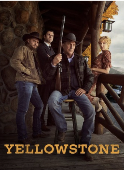
Another beneficiary of this domestic migration is Montana. On a per capita basis, it has the third-highest rate of net domestic migration, and as with Florida, a common political narrative is that tens of thousands of people moved there the last few years because they were fed up with COVID restrictions.
These new residents have been seen as a factor making the state’s politics redder, as the GOP completed their conquest of the state with Senator Jon Tester’s 7-point loss to Republican challenger Tim Sheehy. Fun fact: MT-SEN 2024 was the most expensive congressional election in US history relative to the number of votes cast - nearly $500 was spent for every vote.
Montana is still thinly populated. Despite its extensive land area, it only has about 1.14 million people, less than 8 per square mile. Nonetheless, this number is rapidly growing as more people are inspired by shows like Yellowstone to move to Montana and live out their cowboy fantasies. It’s a bit ironic, too, because from what I understand, Yellowstone is an allegory for how out-of-staters shouldn’t be moving to Montana and ruining it for the natives. And yet it’s contributed to the real-life gentrification of the state!
It is worth noting, of course, that the United States is not the only country with a center of population. I’m not going to engage in unnecessary “USDefaultism” here, so let’s look at this map from the CIA World Factbook:

As you can see, the point on Earth closest to the average person is in what appears to be northern Pakistan - it’s an average of about 3,000 miles to everyone else. Given how populated South Asia, and Asia in general, is, this isn’t much of a surprise. By contrast, the farthest point from each person is just off the western coast of Chile. That’s where you’d end up if you dug a hole all the way through.
So what are the takeaways from the center of population concept? Well, I think it’s a reminder that there are very real pressures driving people to move to certain parts of the world and not others. My own state’s center of population isn’t that far west of Boston (it’s in the town of Natick). This is of course not uniform - there are people who’d rather live in rural areas. They may not be a majority, but they exist. Still, over time, we should expect the urban percentage of the population to increase.
Thank you for reading.
Why The Alps Are (Probably) More Popular Than The Rockies
There are many mountain ranges in this world, many of which offer stunning views and the potential for outdoor activities. Some of these have more tourism infrastructure than others. Two of the most famous ranges in this regard are the Alps, running across the spine of Europe from France to Slovenia, and the Rocky Mountains, which stretch from Northern Alberta all the way to New Mexico.
Now, precise numbers about how many tourists visit the Alps as opposed to the Rockies are very difficult to come by. I do mostly cursory research for my articles, so I couldn’t be bothered to sift through endless academic journals to find exact statistics. The easiest stats to find are at the country level , meaning that it’s apples and oranges.
However, most of what I’ve seen appears to suggest that the Alps are more popular with international tourists than the Rockies. In this post, I’ll examine a few reasons why that may be the case.

A photograph I took from Copper Mountain, Colorado in March 2024.
First of all, considerably more people live in Europe than North America - more than 740 million for the former as opposed to 590 million in the latter. The Alps are simply closer to more people than the Rocky Mountains. However, this is admittedly a crude way of looking at the question, so let’s look at it in terms of cities.
The largest city close to the Alps would be Munich, Germany, which has a population of almost six million in its metro area. There are also several decently-sized cities in Switzerland, Austria, Italy, and France that can qualify as being “in the Alps.” What I’m trying to illustrate here is that the Alps are located near multiple population centers that have airports and train stations. From Boston Logan, I can fly directly to Munich or Zurich and be there in about 7 hours, and then easily take the train to the Alpine town of my choosing.
By contrast, the Rockies are not as easily accessible to someone visiting from Europe. While one can fly to Denver from Frankfurt, Munich, Paris, or London, Denver is the only major U.S. airport close to the Rockies, and even then it’s a decent drive. And because Amtrak is a national shame, you will have to drive there yourself.
There are also the Canadian Rockies, in which case one can fly from any of the aforementioned four European cities to Calgary, Alberta. Some people, like Not Just Bikes, say that Via Rail, the main Canadian rail system, is even worse than Amtrak. There’s also the Rocky Mountaineer train, but that’s strictly for sightseeing, not for anyone who wants to get to their destination in any reasonable amount of time.
Even in the summer, driving in a country you don’t live in can be stressful, but the high mountain roads of the Rockies can become downright treacherous in the winter months. And that’s something you just don’t have to deal with in the Alps, because Europe has actually invested in its rail service.

Conditions are frequently like this on I-70 in Colorado in the winter.
Now let’s get to another factor, which is the culture of each region. The Alps are split between several countries; excluding the microstate of Liechtenstein, you’ve got Austria, France, Germany, Italy, Slovenia, and Switzerland. As such, a trip to the Alps allows one to visit multiple countries in one go, and every country brings its unique culture to the table.
Meanwhile, the Rockies are only split between two countries, Canada and the United States. Now, many Canadians on Reddit will gladly tell you everything that makes their country culturally different from the United States, and they might well be correct where sanity is concerned. But the fact remains that a trip to the Rockies may not be as culturally enriching as the European alternative.
For instance, one important difference between the Alps and the Rockies is that in general, Alpine ski resorts were built around existing towns long before downhill skiing was a thing. These towns include, but are not limited to, Val d’Isere and Chamonix in France, Sankt Anton am Arlberg in Austria, and any number of locations in Switzerland. Because of this, there’s a lot more traditional Alpine architecture in Europe.
By contrast, most of the “villages” surrounding ski resorts in the United States and Canada were purpose-built just to serve the resort. One example is Vail, which was clearly built to evoke the capital-A Alpine charm, but just ends up looking so artificial. That’s because it is. And I don’t fault anyone who decides they’d rather visit a town that appears authentically European because it’s actually in Europe.

Vail Village in Colorado, United States. Image taken from East West Hospitality.

Val d’Isere, France. Image taken from the Alpinium Ski Resort Guide.
Now let’s talk about the elephant in the room, which is the political situation in the United States. Obviously this doesn’t apply as much to potential visitors to the Canadian Rockies, but the American Rockies might see a decrease in tourism in light of the reelection of Donald Trump to the U.S. presidency. I think that, in the context of how alpine tourism will be impacted by climate change, some people will boycott the United States due to their electing a climate denier to the highest office in the land.
Even if Trump hadn’t won, though, gun violence would remain a concern. The United States has a much higher crime rate than almost anywhere in Europe, certainly in terms of violent crime. Quite a few countries have issued travel warnings against us, and for good reason. But to be clear, our reputation is in the toilet, and we deserve it.
Now, how many people who otherwise wanted to visit the United States will boycott it just because Trump won? I truly don’t know. It was reported in 2018 that $4.6B in tourist revenue was lost under his first presidency. That is a relatively small fraction of the total, of course, and it’s not like a gradual decline in international tourism is going to tank the American economy on its own. But I think it’s a notable barometer of where sentiment is at.

The U.S. Embassy in London after Just Stop Oil protestors vandalized it with orange paint.
In conclusion, those are a few reasons why tourism to the Rockies is generally less than that to the Alps. They are both stunning mountain ranges, but one is more accessible than the other, one is more culturally rich than the other, and one has a more favorable political situation than the other. Of course, a lot of this is conjecture - if anyone reading this wants to offer their own theories, they are welcome to do so.
Thank you for reading.
What Is The Alaska Of Your Country?
If you’re in the United States (or oftentimes, even if you aren’t), Alaska needs no introduction. It’s called the Last Frontier for a reason.
Alaska was the 49th state to be admitted to the U.S. in 1959. At the time, the population was about 220,000 people according to Wikipedia. As of 2023, Alaska has a population of over seven hundred thousand people.This might sound like a dramatic increase, and it is, but it is still the third-least populous state overall. Its low overall population comes in spite of its expansive geographic area - it’s larger than Iran! And if it were an independent nation, Alaska would be bigger than all but sixteen countries.
Perhaps because of its isolation and outlier status in terms of population density, Alaska’s made quite the impact on popular culture. As a child, one of my favorite animated movies was Balto. I need to watch it again, come to think of it. That film was one reason my sister had always wanted to visit Alaska, a trip my family made in 2016.
It’s not just children’s movies that have put Alaska on the map. There are any number of reality shows that have done the same. There was that cringe-worthy series Ultimate Survival Alaska that ran for three seasons, essentially a poor man’s Amazing Race that was probably staged five ways from Sunday. Then there’s Alaska State Troopers, which I have not seen, but apparently documents the challenges experienced by law enforcement in such a vast territory.

TV thumbnail for Ultimate Survival Alaska.
All of these statistics might make one wonder: Do other countries have their own version of Alaska?
Obviously, not every nation has a polar region. For the sake of this article, “Alaska” can be seen as a metonym for a sparsely populated administrative division of a given country that is also relatively expansive in terms of area. Beyond the literal Alaska, as it turns out, quite a few countries have a figurative Alaska.
Let’s look at Germany, a country I have a few online friends from. By population density, the German state ranked last is Mecklenburg-Vorpommern . It’s situated in the northeastern part of the country, bordering Poland and the Baltic Sea. Its capital is this beautiful-looking city called Schwerin that, according to Wikipedia, has just 96,000 residents. It probably feels somewhat like a small town, though how should I know? I’ve never been there.

Schlossbrücke in Schwerin, Mecklenburg-Vorpommern, Germany.
Like many rural areas of the United States, it appears Schwerin is relatively right-wing in terms of its voting patterns. Now, for the most part, the right-wing in Europe is nothing like the Republican Party we have in America. However, the far-right AfD party won a 26% plurality of the vote, and roughly that percentage of seats, in the most recent city council election.
Another interesting fact I learned about Schwerin while writing this article is that it is the city with the highest crime rate in Germany. However, this statistic is somewhat misleading, because it’s the only city in the country where riding public transit without a ticket is counted in the crime statistics.
Of course, calling Mecklenburg-Vorpommern the Alaska of Germany is a relative term. Its population density is 69 people per square kilometer as of the end of 2018, and it has possibly grown since then. For frame of reference, that’s nearly twice the population density of the United States as a whole.

Aerial view of Niseko, Hokkaido, Japan. Image taken from the Niseko Tourism website.
Now let’s talk about Japan. It’s another beautiful country that I had the honor and privilege of visiting about two years ago now. That vacation was mostly a ski trip in the Hakuba Valley region of Nagano Prefecture. Not only is it a gorgeous place, but the food is amazing - the apple juice tasted like real apples!
In all seriousness, Japan’s answer to Alaska is Hokkaido. It’s the northernmost prefecture and is relatively sparsely populated. Again, it’s all relative, as Japan has a much higher population density than the U.S. overall. Hokkaido’s capital is Sapporo, a city known for its beer and its annual snow festival.
This island is not only among the most sparsely populated parts of Japan, but it’s one of the snowiest places in the world, at least among those inhabited by any significant number of people. The city of Sapporo itself received almost five meters of snow in the average year between 1991 and 2020. And that’s just the largest city on the island, the place that likely has relatively hospitable winters compared to other parts of the prefecture.
Many other places on Hokkaido, such as the world-renowned ski area of Niseko, receive considerably more snow. In fact, Hokkaido in general is known for winter sports. Most of the ski resorts in Japan are fairly Westernized, but from what I’ve heard, Niseko is quite popular with Australian tourists. It’s to the point where you’ll hear “G’day mate” more often as a greeting than “Konichiwa”.
So Hokkaido is undoubtedly the Alaska of Japan. However, at 61 people per square kilometer, it’s still denser than the United States’ average, and way denser than Alaska. I’ll go with a third example of “it’s all relative.”

Kayangan Lake, Coron Island, a popular tourist attraction in Palawan. Image taken from Wikipedia.
The third case we’ll look at is Palawan. It’s the westernmost province in the Philippines, itself a very densely populated country. Palawan is the largest province by area, as well as having the third-lowest population density if the provincial capital of Puerto Princesa is excluded.
As you can probably tell from the image, Palawan has a vastly different climate from Mecklenburg-Vorpommern, Hokkaido, or especially Alaska. It is what many consider a tropical paradise, and it contains several popular resort cities like Coron and El Nido. Supposedly it’s one of the world’s best places for scuba diving.I’ll admit scuba diving isn’t really my thing; skiing is more my sport. But lots of people scuba dive in Palawan.
The “tropical Alaska” parallels don’t stop there. Palawan is sometimes referred to as the Philippines’ “last frontier” due to its biodiversity and relative isolation from the rest of the country. It’s relatively difficult to reach from more densely populated islands in the archipelago; most travelers have to fly from Manila or Cebu to Puerto Princesa, then possibly take a 6-hour bus ride to El Nido. Coupled with how far away the Philippines already are from the eastern U.S., my rear end is getting sore just thinking about a trip I haven’t even planned to take.
Overall, one thing I find fascinating is that many of these “miniature Alaskas” their respective countries are popular tourist destinations. I don’t know how many people visit Mecklenburg-Vorpommern for leisure, especially those traveling to Germany from thousands of miles away. But Hokkaido is well-known for ski tourism, and Palawan gets a considerable number of scuba divers and other tourists who love the beach. I’d imagine many of the latter’s visitors are from elsewhere in the Philippines, but still.
I think there’s something to be said about visiting places with relatively sparse populations. Yes, there are many reasons why a majority of the world’s population lives in cities. There are economic pressures leading to population growth, cities have more resources that people need, and it’s even more environmentally friendly to live in a city.
Perhaps, however, the reason so many of these “Alaskas” are tourist destinations is the novelty. If I could travel to an exact replica of Boston in Europe, I would rather just stay at home. It’s the same reason you shouldn’t get McDonald’s as a tourist in Japan; wouldn’t you rather eat something you can’t get so easily at home? People ideally travel for something different from what they’re used to.
Alaskan Ski Resorts: Why Aren’t There More Of Them?
I’ve decided that I want to start this blog up again (I’m still paying for the domain, after all - might as well use it), but I’m going to switch it to being about geography, at least for the time being. Quite frankly, politics get pretty depressing after a while.
Recently I saw a Reddit thread asking why Alaska had very few ski resorts. This was a question that fascinated me to no end, because for those of you who don’t know, I am an avid skier, having participated in the sport since I was 6 years old.

A topographical map of Alaska, taken from Earth@Home.
As you can see, the state is quite mountainous. In fact, it contains the highest peak in North America, Denali (which was named Mount McKinley until then-President Barack Obama restored the indigenous name for the mountain.) Fun fact, I actually have met someone who served as a Denali guide, though that’s a story for another time.
Not only does Alaska have a lot of mountains, it’s also got a lot of snow in the winter. Many of the mountains even have snow in the summer. Based on that, one would think the state is fertile ground for a ski resort. In fact, however, there are only 10 ski areas in Alaska with Wikipedia articles , a number that seems far too low for the largest state in the country by area. For frame of reference, Colorado, which has less than a sixth of Alaska’s area, has 35 notable ski areas. But as global warming threatens our beloved sport in Colorado, colder places that get more snow now will increasingly become more popular…right?
In other words, Alaska “should” have more than two hundred ski resorts if they were distributed evenly across the state. However, it doesn’t. So why not?
First of all, let’s consider one thing that won’t change no matter how much the climate warms: The length of the day. In my experience, most ski resorts I’ve been to close around 4 PM - that’s when the last skiers are allowed to get in line for the lift. Without totally doxxing myself, I live at about 42°N, and on the day I’m writing this (December 5, 2024), the sun rose at 6:59 AM and will set at 4:12 PM. That’s 9 hours, 13 minutes of daylight. During winter, the days are shorter; who woulda thunk? And crucially, the winter days get shorter the further north you go.
At 42 degrees north, the shortest day of the year is slightly over 9 hours long. However, in Anchorage, Alaska’s largest city, the sun doesn’t rise until almost 10 AM this time of year, and it sets just under six hours later. That’s just six hours of daylight, which may not be long enough to make a ski resort economically viable. And the further north you go in Alaska, the more limited the light will become. It just doesn’t make sense to run a ski resort that’s only open a few hours a day, and night skiing isn’t possible (or safe) everywhere.
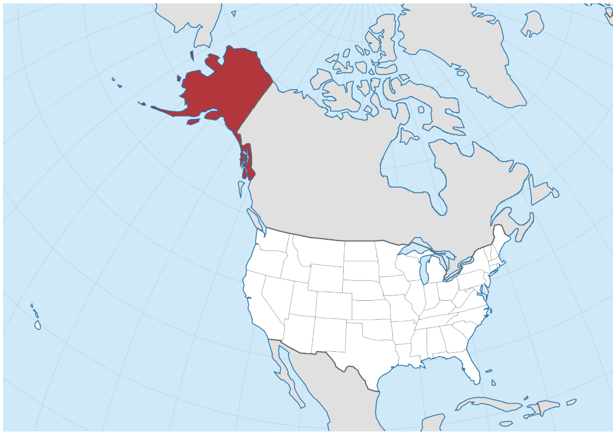
Now look at this map. It’s from Wikipedia and shows Alaska highlighted in red. Given that, you can see just how far it is from the rest of the United States. The closest major U.S. airport to Alaska is Seattle/Tacoma (SEA), and even that flight from Seattle to Anchorage has a block time of 3 hours, 50 minutes. Ted Stevens International Airport (ANC) does maintain flights to some major cities in the American West, as well as Minneapolis-Saint Paul (MSP), but those are even longer than the one from Seattle.
The only regularly scheduled international route to or from ANC, for now, is Frankfurt, Germany (FRA). This route is operated by German leisure airlines Condor and Discover Airlines; however, both are only seasonal. And that season is summer, which is not ski season, even in Alaska. I don’t know how many Europeans would want to visit Alaska anyway when Norway is a more politically stable (and perhaps more importantly, much closer) alternative. But with no direct flights during the winter, I’d imagine that’s a very limited market for ski tourists to the Last Frontier.
To put this into perspective, imagine that you live in Greater Boston, like me. If I want to go for a ski trip in the American West starting on January 20, I could either go to Denver in 5 hours or less for $250/ticket, or I could go to Anchorage and be there in 12 hours or more for $600/ticket. Yes, I looked it up; that’s the quickest way. Considering the limitations faced in terms of daylight, as well as the fact that things in Alaska are more expensive, most people in such a position will choose Colorado. And that’s doubly so for those in Europe, who have plenty of ski resorts in the Alps.

Aerial photo of Copper Mountain in Colorado showing how much infrastructure it takes to run a ski resort. Taken from Ski.com.
The last reason I’ll touch on is the cost. Not the cost borne by those who would ski at these hypothetical Alaskan resorts, but rather the cost borne by those who are going to build the resorts.
A ski resort takes lots of time and money to set up. I’ve never been involved in the process of developing one, but I’d imagine that anyone who wants to would need to get environmental permits squared away. Who knows how much money that takes. And that’s before the lifts are built, which not only takes money, but also labor. Plus, most ski resorts in North America build “villages” at the base like the one pictured above - you need building permits (money), the salaries of people who staff the businesses (money), and upkeep (money).
As monetarily expensive as it may be to run a ski resort, labor is the real problem here. As my country has “learned” time and time again, you can throw as much money as you want at a problem, but if you don’t have enough people to work on a project, it will never be built. There’s a reason this country has a teacher shortage that is only likely to get worse.
At the time of writing, Alaska is the third-least populous U.S. state, with about 733,000 people in 2023. It is, by a factor of nearly five, the most thinly populated state relative to its geographic size, and that won’t change anytime soon. Employers in industries we might consider more essential than running a hypothetical future ski resort have already faced problems filling positions. They’ve turned to labor from outside the state. It sort of reminds me of how some young Australian adults work as ski instructors at resorts in Canada like Banff and Whistler. However, the sort of mass ski tourism some would envision in Alaska would require out-of-state labor (and sometimes out-of-country labor) on a far greater scale.
In my opinion, if Alaska is going to gain a labor surplus sufficient to build new ski resorts (let alone dozens of them), the only thing that would really cause that is an increased AI boom. AI, of course, is problematic enough on its own - we’re already seeing these problems. Is it really worth training artificial intelligence to build ski resorts when there are more pressing issues to deal with?
All of the above being said, Alaska is a beautiful state that I believe is worth visiting if you can spare the effort and expense to get there. There are many types of nature tourism that can thrive there, but ski tourism likely isn’t one of them.
Blog Post Title One
It all begins with an idea.
It all begins with an idea. Maybe you want to launch a business. Maybe you want to turn a hobby into something more. Or maybe you have a creative project to share with the world. Whatever it is, the way you tell your story online can make all the difference.
Don’t worry about sounding professional. Sound like you. There are over 1.5 billion websites out there, but your story is what’s going to separate this one from the rest. If you read the words back and don’t hear your own voice in your head, that’s a good sign you still have more work to do.
Be clear, be confident and don’t overthink it. The beauty of your story is that it’s going to continue to evolve and your site can evolve with it. Your goal should be to make it feel right for right now. Later will take care of itself. It always does.

Blog Post Title Two
It all begins with an idea.
It all begins with an idea. Maybe you want to launch a business. Maybe you want to turn a hobby into something more. Or maybe you have a creative project to share with the world. Whatever it is, the way you tell your story online can make all the difference.
Don’t worry about sounding professional. Sound like you. There are over 1.5 billion websites out there, but your story is what’s going to separate this one from the rest. If you read the words back and don’t hear your own voice in your head, that’s a good sign you still have more work to do.
Be clear, be confident and don’t overthink it. The beauty of your story is that it’s going to continue to evolve and your site can evolve with it. Your goal should be to make it feel right for right now. Later will take care of itself. It always does.
Blog Post Title Three
It all begins with an idea.
It all begins with an idea. Maybe you want to launch a business. Maybe you want to turn a hobby into something more. Or maybe you have a creative project to share with the world. Whatever it is, the way you tell your story online can make all the difference.
Don’t worry about sounding professional. Sound like you. There are over 1.5 billion websites out there, but your story is what’s going to separate this one from the rest. If you read the words back and don’t hear your own voice in your head, that’s a good sign you still have more work to do.
Be clear, be confident and don’t overthink it. The beauty of your story is that it’s going to continue to evolve and your site can evolve with it. Your goal should be to make it feel right for right now. Later will take care of itself. It always does.

Blog Post Title Four
It all begins with an idea.
It all begins with an idea. Maybe you want to launch a business. Maybe you want to turn a hobby into something more. Or maybe you have a creative project to share with the world. Whatever it is, the way you tell your story online can make all the difference.
Don’t worry about sounding professional. Sound like you. There are over 1.5 billion websites out there, but your story is what’s going to separate this one from the rest. If you read the words back and don’t hear your own voice in your head, that’s a good sign you still have more work to do.
Be clear, be confident and don’t overthink it. The beauty of your story is that it’s going to continue to evolve and your site can evolve with it. Your goal should be to make it feel right for right now. Later will take care of itself. It always does.